


Hiking Trails Table of Contents
Hiking opportunities are abundant in Missouri. A hiker in this state can experience everything from a difficult climb up an Ozark Mountain peak to an easy stroll along the Missouri River. Missouri has a large amount of public land, and many of these public areas are home to extensive trail networks. Most of the trail mileage in Missouri is found in the Ozarks. The Ozark region is home to hundreds of miles of hiking territory, including the famous "Ozark Trail". The trail system in the Ozark Mountains leads across river valleys, mountains, glades, and ridges. Truly, the Missouri Ozark region provides some of the most enjoyable hiking in the nation.
While most of the trail mileage in Missouri is found in the Ozarks, there are beautiful hiking trails throughout the state. Conservation Areas and State Parks provide most opportunities. Some areas have marked, official trails, while others simply have a network of logging roads that you will have to map out for yourself. But no matter where you are located, you can find some enjoyable hiking nearby. Our hiking portion of the website will give you locations, tips, and other ideas that will help you enjoy the trails in our state.
- Bell Mountain Wilderness Area
- Berryman Trail
- Green Rock Trail
- Lewis and Clark Trail
- Hawn State Park Trail
- Cuivre River State Park Trails
- Babler State Park Trails
- Meramec State Park Wilderness Trail
- Johnson's Shut-Ins State Park Trails
- Chubb Trails
- Castlewood State Park Trails
- Taum Sauk State Park Trails
- Rock Pile Mountain Wilderness Trails
- Rockwoods Reservation Trail System
- Howell Island Conservation Area Trails
- Forest 44 Conservation Area Trail
- Greensfelder County Park Trails
- St. Francois State Park Trails
- Cliff Cave County Park Trail
- Council Bluff Lake Trail
Hiking In Bell Mountain Wilderness
The Ozark Trail is concurrent with the Bell Mountain Trail for about a mile into the Wilderness. Then the Bell Mountain Trail turns north and ascends the 1,702-foot peak of Bell Mountain. A Wilderness is a special area set aside by Congress which "generally appears to have been affected primarily by the forces of nature with the imprint of man's work substantially unnoticeable?" The area is rugged and is for experienced hikers only. Before you start, be prepared with adequate supplies; water sources within the Wilderness are not recommended for drinking. To enhance solitude, groups are limited to a maximum of 10 people. A separate two-mile trail begins at the end of Forest Road 2359 on the east side and leads to the top of Lindsey Mountain. Both sections offer breathtaking views of the surrounding area. The tall peaks of the St. Francois region extend southeasterly. Between Bell Mountain and Lindsey Mountain lies Shut-in Creek, a spring-fed stream with several gorges along its course; these gorges are locally called "shut-ins" a result of the unyielding resistance of igneous rock to water erosion.
Joe's Creek cuts deeply into the west slope of Bell Mountain; clefts and boulders form the basic landscape. St. Francois Mountains, one of oldest landforms in North America, has a combination of plant and animal communities not found in other areas of the Ozarks. Gnarled blackjack and post oak, black hickory, and a few winged elms are found in the harsh environment of the granite glades. The native grass supports unique and interesting life forms. Pileated woodpeckers, wood thrush and ovenbirds are abundant. White tailed deer, wild turkeys and squirrels can be found.

How to get here:
FT 12 Trailhead:
from Potosi, MO, take Hwy 21 South 18 miles to Hwy 32. Take Hwy 32 West 8 miles to Hwy A.
Take Hwy A South approx 1/4 mile to first Forest Road SE Go approx 1/4 mile SE to site.
Hwy A Trailhead:
from Potosi, take Hwy 8 one mile East to Hwy 21. Go South on Hwy 21 for 11 miles. Or take Hwy 21 South for
17 miles to Hwy 32. Take Hwy 32 West for 8 miles to Hwy A. Take Hwy A approx 5 miles South to site.
Berryman Trail
This trail traverses 24 miles of scenic Ozark countryside starting at the site of a Civilian Conservation Corps camp of 1937 and winding through timbered stands and fields. The hiking, mountain biking, and horseback riding offer one a pleasant measure of solitude and quiet. Two small primitive campgrounds are available for use.
Top of Page
Green Rock Trail
Green Rock Trail is located primarily in Greensfelder Park in St. Louis County. The trail is a one way trail
and is right at 10 miles in length. It is of a moderate to difficult level for the average hiker. The average hiker
will require in the neighborhood of 6 hours of actual hiking. Bring plenty of water and food, and be prepared to
share the trail with equestrian users.
Location:
Trailhead at Rockwoods Range just west of Six Flags, Allenton, MO along Fox Creek Road. Trail ends at
Rockwoods (MODOC) Education Center on Glencoe Road.
Lewis and Clark Trail
Hawn State Park Trails

Whispering Pine Trail - 10 miles
Whispering Pine Trail was constructed in 1976 and 1977 with the help of the Ozark Chapter of the Sierra Club.
This effort has resulted in what is generally considered to be one of the best hiking and backpacking trails in
the state. The trail consists of two loops: the north loop is approximately six miles long and the south loop
is approximately four miles. The trail provides the opportunity for day hikes of varying lengths or a longer
backpacking trip. It meanders through a beautiful mixed hardwood and pine forest, which is home to a variety of
animals such as bobcat and wild turkey. Extensive exposures of sandstone and granite can be explored along the
banks of Pickle Creek and the River Aux Vases. Mosses and ferns create a luxurious effect on the moist
overhangs that occur along the two streams. Whispering Pine Trail can be reached by turning left at the park
entrance and proceeding to the picnic area where a parking area is provided. Water is not available at the
trailhead, but can be obtained at the park office or the campground.
Pickle Creek Trail - 1 mile
Pickle Creek Trail begins at the picnic area located between the park office and the campground. The entire
trail follows Pickle Creek, which is a beautiful shut-ins stream. This persistent stream has carved its way
through the surrounding sandstone to its present course. The result is a clear, sandy-bottom creek strewn with
water-sculpted granite boulders and numerous exposed sandstone bluffs. The trail provides a point-to-point hike,
although a loop hike is possible by returning on a portion of Whispering Pine Trail that traverses the bluffs
on the opposite side of the creek.
Overlook Trail - 0.25 mile
This short trail leads to a small overlook of Pickle Creek valley, with a view of some of the pine and
oak-covered hills in Hawn State Park. Along the path, you will find interpretation about the pine woodlands
that grace its vistas; and the Lamotte Sandstone that forms its bluffs, knobs and box canyons.
White Oaks Trail - 4.4 miles
White Oaks Trail begins at the park entrance where Highway 144 ends. This trail crosses several wet-weather
creeks and has scenic views from large exposed sandstone rock outcrops. It travels through a diverse mixed
hardwood and shortleaf pine forest. Deer, wild turkey, and owls may be seen or heard along the White Oaks Trail.
This is a day-use trail only. No overnight camping is allowed along this trail.
Directions to Hawn State Park
From St. Louis
Hawn State Park is 60 miles south of St. Louis and 20 miles west of Ste. Genevieve. From south St. Louis, take
I-55 south to Exit 150. Exit onto Hwy. 32 and travel west 11 miles to Hwy. 144. Turn left onto Hwy. 144 and
travel 4 miles to reach the state park.
From Farmington
Hawn State Park is 13 miles east of Farmington. Take Hwy. 32 east 9 miles to Hwy. 144. Turn right onto Hwy. 144
and travel 4 miles to reach the state park.

Cuivre River State Park Trails
Hamilton Hollow Trail -- 1 mile
Hamilton Hollow Trail is a loop that begins and ends near the picnic shelter. A wide array of spring wildflowers
and some of the largest trees in the park, many over 150 years old, are in the hollow. This trail is marked
with green arrows in a clockwise direction.
The northern part of this trail is shared with Cuivre River Trail, on which equestrian use is allowed; the
remaining sections of Hamilton Hollow Trail are closed to horse traffic. Hamilton Hollow is an easy trail to
hike.
Frenchman's Bluff Trail -- 2 miles
This popular trail begins and ends near the west side of the picnic shelter. The trail follows Goedde Creek for
a short distance before winding up a hill and emerging on top of Frenchman’s Bluff. The 120-foot-high bluff,
consisting of Burlington limestone, offers outstanding vistas of the Cuivre River valley. After continuing
along the bluff for approximately half a mile, the trail returns to the picnic shelter. This trail is
relatively easy to hike, but extreme care should be taken when on top of the bluff as the loose gravel can
make the footing unsure. Blue arrows mark the trail in a counterclockwise direction. The valley portion of
the trail is shared with the Cuivre River Trail. The bluff portion of this trail is open to equestrian use.
Cuivre River Trail -- 7 miles
Cuivre River Trail begins at the equestrian camp and proceeds along Goedde Creek before ascending to the top
of Frenchman’s Bluff. At this point, Cuivre River Trail turns right and proceeds north along the entire length
of the bluff. The trail eventually heads east to descend into the Big Sugar Creek valley. It follows the valley
most of the way back to its original starting point. This moderately strenuous trail is open to hikers,
backpackers and equestrians. It is marked with red arrows in a clockwise direction. White arrows mark
connector trails that can be taken if shorter hikes or rides are desired. Horses are not permitted in the
picnic area.
Big Sugar Creek Trail -- 7 miles
The trailhead for Big Sugar Creek Trail is located on the west side of the park road, midway between Camp
Derricotte and Camp Sherwood Forest. The trail traverses much of Big Sugar Creek Wild Area, including Sugar
Bluff, a bottomland forest along Big Sugar Creek. The trail also passes through steep fern- and moss-covered
hollows dissecting the watershed. This moderately strenuous trail is open to hikers, backpackers and to
equestrians on the southern half. Shorter hikes of four miles are possible by using the white connector trails.
The trail is marked with blue arrows in a clockwise direction.
Turkey Hollow Trail -- 1 mile
Turkey Hollow Trail begins and ends at the Sugar Creek Valley Overlook. The trail is a loop, marked in a
counterclockwise direction, with a common entrance and exit. The first part of the trail passes through an old
field before entering a nice upland forest with many large oak trees. It then crosses a bridge over a small
valley and loops around the point of a ridge before heading back toward the overlook tower. Turkey Hollow Trail
is named for the wild turkeys that have frequently been seen in the area. This is an easy trail to hike,
however, the last part of the trail does have an uphill grade.
Mossy Hill Trail -- 1 mile
Mossy Hill Trail begins on the electric campsite side of the campground. It has the same entrance and exit,
and then separates to provide a half-mile loop. After following a wooded valley, the trail crosses Mossy Hill,
an open forest with luxuriant growths of mosses and lichen, especially the reindeer lichen. Mossy Hill is an
easy hiking trail. It is signed in a clockwise direction.
Lone Spring Trail -- 6 miles
Lone Spring Trail consists of two three-mile loops, one north and one south of Highway KK. The trail is named
for a perennially flowing spring that emerges in the valley at the base of a ridge. The northern portion of
Lone Spring Trail, which is open to hikers and backpackers only, loops through Northwoods Wild Area and crosses
Big Sugar Creek, a designated state natural area. The southern loop of this trail is particularly nice in the
spring when the dogwood and wildflowers are in bloom. This moderately strenuous trail is marked with yellow
arrows in a clockwise direction. A connector trail, which allows the option of a three-mile hike, is marked
with white arrows. Trail parking is provided along Highway KK.
Lakeside Trail -- 4 miles
Lakeside Trail, following the entire shoreline of Lincoln Lake, is frequently used by fishermen. During the
summer, a good display of wildflowers can be found between the trail and the edge of the lake. Hikers may
enter the trail at either the boat launch ramp or swimming beach. Lakeside Trail is signed only at the
entrances, but is easy to follow and to hike.
Prairie Trail -- .2 mile
Prairie Trail is an easy hiking trail winding through the Sac Prairie, which is located about one-fourth mile
south of Camp Sherwood Forest’s entrance road. This special area will give hikers a glimpse of the vast
prairies that once covered more than a third of Missouri in pre-settlement times. The trail entrance is
located at the Sac Prairie parking lot. A bulletin board at the trail entrance will provide hikers with more
information about the prairie and preservation efforts.
Blazing Star Trail -- 2 miles
The trail begins on the southern side of Sac Prairie, near where the Prairie Trail starts. After crossing
through a wooded creek valley, the trail enters an open expanse of tallgrass prairie. It then alternates
between wooded savanna and open prairie, until the loop returns you through the creek valley and back up to the
parking lot. Note: A separate trail entrance connects the trail loop to the campground. Summer and fall are
the best times to see many of the wildflowers, while the tall prairie grasses reach their peak during the
fall. Occasionally, the trail may be closed for a prescribed burn to preserve the prairie, savanna and
woodland ecosystems.

Directions to Cuivre River State Park
From St. Louis
Travel west on I-70 or U.S. Hwy. 40 to Exit 210/Wentzville. Take U.S. Hwy. 61 north for 14 miles to Troy.
Travel east on Hwy. 47 for 2.8 miles to Hwy. 147, which is the main entrance to the state park.
From Jefferson City
Travel east on I-70 to Exit 210/Wentzville. Take U.S. Hwy. 61 north for 14 miles to Troy. Travel east on Hwy.
47 for 2.8 miles to Hwy. 147, which is the main entrance to the state park.
From Springfield/Rolla
Travel east on I-44 to Exit 276/St. Louis. Take I-270 north for 6.6 miles to U.S. Hwy. 40. Travel west on U.S.
Hwy. 40 to Exit 210/Wentzville. Take U.S. Hwy. 61 for 14 miles to Troy, then go east on Hwy. 47 for 2.8 miles
to Hwy. 147, which is the main entrance to the state park.

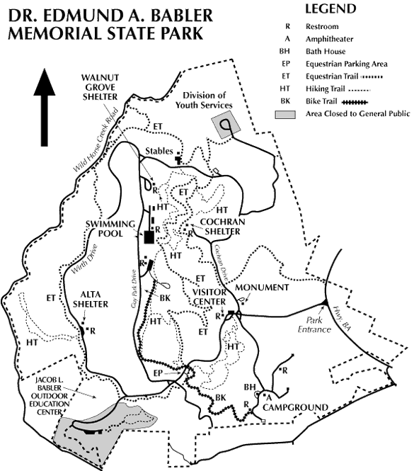
Babler State Park Hiking Trails
Hawthorn Trail -- 1.25 miles
This trail takes the hiker along the northeast side of a narrow ridge and returns on the southwest side. A marked difference in plants and habitat is found on the two aspects of the ridge. The prevailing hot and dry southwestern winds give an almost gladelike appearance to the section of trail along the side of the ridge facing the southwest. The soil is dryer, plants are sparser and in many areas, the underlying rock is exposed. On the northeast side, plants are thicker and greener, the soil is deeper and groves of pawpaw trees flourish on the slope and in the valley below the trail.
Dogwood Trail -- 2 miles
This is probably the most strenuous of the four trails. It rises and falls several times over the maximum altitude change in the park, about 300 feet. The trail head serves both Dogwood and Woodbine trails and the two trails can easily be combined for a longer hike. Chert, flintlike rock is exposed in some of the slopes of dry ridges on this trail. The hiker is also taken through moist, green valleys in the low sections of the trail and heavily wooded sections on the northeast side of the trail. At the highest point, the trail passes a stone picnic shelter and restroom, remnants of the work done by the Civilian Conservation Corps (CCC) when the great depression-spawned group used the park as a camp in the 1930s.
Woodbine Trail -- 1.75 miles
This trail starts in the north-south valley that intersects the park and soon starts uphill, sharing a section of a paved bike trail that runs through the woods. It is on this sheltered section of the trail that the moist runoff creek that parallels the trail provides verdant foliage. Pawpaw, spicebush, jack-in-the-pulpit, trillium and other deep green plants grow along each side of the trail. Near the top of the hill, the trail departs the bike path and crosses a footbridge. Across the bridge, the trail traverses a ridge that gets plenty of sunshine and provides some of the earliest fall color for viewing.
A fine lady, for whom this trail is named, spent some of the last years of her life as a volunteer naturalist working at the park. She made a wonderful impression on the young people that visited the park and inspired many of them to study nature with enthusiasm. The trail starts near the park’s visitor center and descends into a valley and to a ridge on the far side of the loop. At that point, a connector trail branches off that can be used to reach the bike path and the Woodbine Trail. Continuing on the trail, the hiker descends back into the valley and reaches the spur that goes back to the trail head. Because of the proximity of this trail to the visitor center, it is used for many nature study programs. Opportunities are provided for observing concepts such as forest layers, changes in tree height from ridge to valley, types of trees at various levels of available moisture, and the process of secondary succession in a recovering forest.
Directions to Dr. Edmund A. Babler Memorial State Park
From Eureka
From I-44, take Exit 264 onto Hwy. 109. Travel north eight miles to Route BA. Turn left and continue two miles; the park entrance is on the left.
From St. Louis
From I-270, turn west onto U.S. Hwy. 40/64 and travel for 9.5 miles to the Long Road exit. Turn left onto Long Road and travel one mile to Wild Horse Creek Road. Turn right onto Wild Horse Creek Road and continue three miles to the Hwy. 109 stop sign. Turn left and travel less than one mile to Route BA; turn right and continue for 1.5 miles to the park entrance.
From St. Charles County
Travel east on U.S. Hwy. 40 to Chesterfield Airport Road (just after crossing the Missouri River bridge). Continue for two miles to Long Road and turn right. Travel one mile to Wild Horse Creek Road, turn right and continue to the Hwy. 109 stop sign. Turn left and travel less than one mile to Route BA; turn right and continue 1.5 miles to the park entrance.
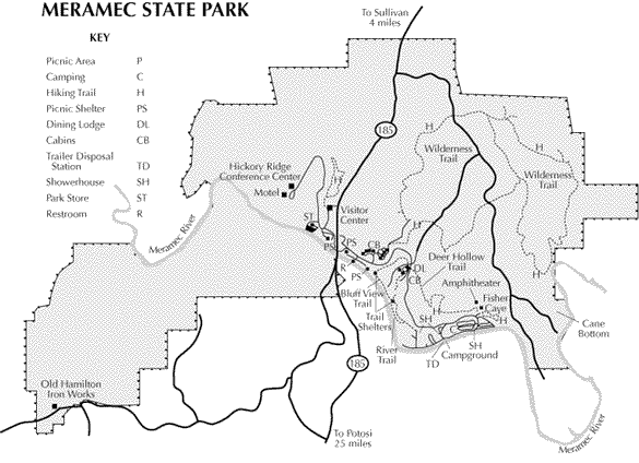
Meramec State Park Hiking Trails
Bluff View Trail -- 1.5 miles
This trail is a moderately difficult loop trail with access points near picnic shelter #3, the dining lodge area and at the trail shelter on River Trail.
Deer Hollow Trail -- 1.8 miles
This trail is a point-to-point trail that connects the dining lodge area to Fisher Cave. Deer are commonly seen along this trail.
Natural Wonders Trail -- 1.3 miles
Caves, glades, mature forest and overgrown beaver meadows are a few of the reasons why there is always something exciting to discover along this loop trail.
River Trail -- .8 mile
This is a loop trail that begins at the southern end of the campground near showerhouse #3. Part of this trail winds along a slough of the Meramec River, where herons frequently feed and kingfishers often nest.
Walking Fern Trail -- .5 mile
This trail's namesake is a large boulder located near the midpoint that is covered with walking ferns.
Wilderness Trail -- 10 miles
This trail is comprised of a six-mile southern loop and a four-mile northern loop. This trail is of moderate difficulty, but due to its length should not be attempted by beginning hikers unless accompanied by someone more experienced.
Directions to Meramec State Park
From St. Louis
Meramec State Park is approximately 1 hour 15 minutes from the St. Louis area. Travel west on I-44 to Exit 226/Sullivan/Hwy. 185 South. After exiting, turn left to travel over I-44 and continue for three miles south on Hwy. 185. The state park entrance is on the right side.
From Cuba/St. James/Rolla
Travel east on I-44 to Exit 226/Sullivan/Hwy. 185 South. After exiting, turn right onto Hwy. 185 and continue for three miles. The state park entrance is on the right side.
From Jefferson City
Meramec State Park is approximately 1 hour 45 minutes from Jefferson City. Travel south on U.S. Hwy. 63 to the Vichy Airport area. Turn east onto Hwy. 68 and continue to St. James; take I-44 east to Exit 226/Sullivan/Hwy. 185 South. After exiting, turn right onto Hwy. 185 and continue for three miles. The state park entrance is on the right side.
Johnson's Shut-Ins State Parks Hiking
Black River Trail
The Black River Trail, the main trail through the day-use area, is an interpretive trail and explains some of the features, including the fen and boulder field. Both the fen and boulder field have pavilions with interpretation and information about why these areas are important.
Shut-Ins Trail
The Shut-Ins Trail features a new boardwalk that provides access to the namesake of the park -- the shut-ins. NOTE: (2/2011) This trail currently is open to the main overlook near the shut-ins; the section past that area is closed.
Scour Trail
The Scour Trail is a new trail that provides access to the scour channel itself. The trail, which is accessed from Route N just east of the main park entrance, is also an interpretive trail that explains the significance of the geology revealed by the scour channel. The trail includes an overlook and interpretive pavilion.
Goggins Mountain Equestrian Trail
The 10-mile Goggins Mountain Equestrian Trail loops through the 5,000-acre Goggins Mountain Wild Area. The trail, free of roads, power lines and other development, is open to hikers and horseback riders wanting to experience the extensive oak-hickory woodland. The trail, marked in yellow, begins at the Goggins Mountain Trailhead just inside the entrance to the campground.
Horseshoe Glade Trail
The 1.5 mile Horseshoe Glade Trail takes visitors into the heart of the East Fork Wild Area. Visitors can experience a sense of wildness as they pass through woodlands dominated by oaks and hickories and dotted with scattered shortleaf pine. Woodlands give way to a rocky clearing that provides views across the St. Francois Mountains. The trail, marked in orange, also passes near a smaller glade overlooking the East Fork of the Black River.
Taum Sauk Section of the Ozark Trail
The 35-mile Taum Sauk Section of the Ozark Trail runs through the heart of the ancient St. Francois Mountains and some of the most scenic areas of this rugged trail are within Johnson's Shut-Ins State Park. The 14.5 miles of trail within the park wind through mountains of oak-hickory woodland dotted with shortleaf pine, bluffs and rocky glades. The Ozark Trail, marked with green and white Ozark Trail markers, is open for hiking, backpacking and backpack camping. (See park staff for restrictions.) Within Johnson's Shut-Ins State Park, the Taum Sauk Section connects with the Goggins Mountain Equestrian Trail and the Scour Trail. Additional information can be found on the Ozark Trail Association website.
Directions to Johnson's Shut-Ins State Park
From St. Louis
Johnson's Shut-Ins State Park is approximately 130 miles from St. Louis (South County); the trip will take about two or two and one-half hours depending on traffic. Take I-270 south to I-55 south. When you get to the Festus area, take U.S. Hwy. 67 south to Farmington. At the second Farmington exit, turn right onto Hwy. 221 toward Doe Run. Travel 17 miles on Hwy. 221 (will merge with Route NN). At the flashing red light, turn right/north onto Hwy. 21. Travel about one-half mile and turn left onto Route N. Go 13 miles on Route N to the park entrance on the left.
From Jefferson City
Johnson's Shut-Ins State Park is approximately three hours driving time from Jefferson City. Go south on U.S. Hwy. 63 to Hwy. 68. Take Hwy. 68 to St. James. You will go through the town of St. James to Hwy. 8. Stay on Hwy. 8 to Potosi. At the intersection of Hwy. 8 and Hwy. 21, turn right/south onto Hwy. 21. Travel approximately 25 miles to Graniteville. Turn right onto Route N. Travel 13 miles on Route N to the park entrance on the left.
From Kansas City
Johnson's Shut-Ins State Park is approximately five to six hours from Kansas City. Take I-70 east to St. Louis. In St. Louis, take I-270 south to I-55 south. When you get to the Festus area, take U.S. Hwy. 67 south to Farmington. At the second Farmington exit, turn right onto Hwy. 221 toward Doe Run. Travel 17 miles on Hwy. 221 (will merge with Route NN). At the flashing red light, turn right/north onto Hwy. 21. Travel about one-half mile and turn left onto Route N. Go 13 miles on Route N to the park entrance on the left.

Chubb Trails
Chubb Trail/Castlewood Loop (black arrows)
10/9/08 -- The Castlewood section of Chubb Trail is temporarily closed due to a bridge outage.
Chubb Trail is a seven-mile (one way) trail that starts at the Chubb Shelter in West Tyson County Park. It passes through a part of Castlewood State Park and goes to the entrance of Lone Elk County Park. The trail is hilly and rugged in West Tyson County Park before entering the river valley. It passes two fields where prairie restoration areas are maintained by the St. Louis County Department of Parks and Recreation and then becomes tightly wedged between a railroad embankment and the river. The trail widens as it enters the bottomland within Castlewood State Park before climbing one big hill to the entrance of Lone Elk County Park. The Castlewood Loop is a three-mile trail that branches off Chubb Trail and further explores the bottomland of Castlewood State Park and the site of Lincoln Beach (swimming beach during the historic resort era). The trail is very flat but it does give some excellent views of the Castlewood Bluff directly across river. The trail is designated for hiking, bicycling and equestrian use.
Directions to Castlewood State Park
From the south on I-44 or I-55
Take the Hwy. 141 exit and travel north on Hwy. 141 to Big Bend Road. Turn left onto Big Bend Road and travel west to Ries Road. Turn left onto Ries Road and continue until reaching the park entrance at the intersection of Kiefer Creek and Ries roads.
From I-270
Take the Dougherty Ferry Road exit and travel west on Dougherty Ferry to Big Bend Road. Turn right onto Big Bend Road and travel west to Ries Road. Turn left onto Ries Road and continue until reaching the park entrance at the intersection of Kiefer Creek and Ries roads.
From the north on U.S. Hwy. 40/61
Take the Clarkson exit (near Chesterfield Mall) and travel south. Clarkson crosses Manchester Road and becomes Kiefer Creek Road which leads into the state park.
From Hwy. 100/Manchester Road (three options)
Take Kiefer Creek Road off of Manchester/Hwy. 100. Kiefer Creek Road will lead into the state park OR Take Ries Road off of Manchester/Hwy. 100. Follow Ries Road to the intersection with Kiefer Creek Road at the park entrance. OR Take New Ballwin Road off of Manchester/Hwy. 100. When New Ballwin Road intersects with Kiefer Creek Road, turn left and continue into the state park.
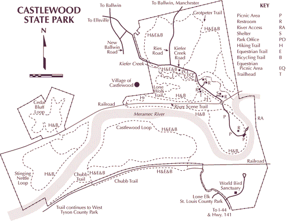
Castlewood State Park Trails Hiking
River Scene Trail (red arrows)
This three-mile loop is the most spectacular trail in the park and highlights the park’s most memorable features. The trail climbs to and then traverses a series of bluffs overlooking the Meramec River. It then goes down a long wood staircase that takes you from the top of the bluffs to the valley below. From there, the trail takes you through an up-close and personal look at the river and the bottomland surrounding it. Along the way, you will pass panoramic vistas, remnants of the historic resort era and floodplain forest. This trail is designated for hiking and bicycling (hiking only on the bluff portion).
Grotpeter Trail (blue arrows)
This three-mile loop follows Kiefer Creek as it meanders through the park. After leaving the creek valley, the trail climbs and then winds through a group of hills adjacent to the creek valley. The trail runs on the north side of Kiefer Creek and also includes several road crossings. Stop, look and yield before crossing any road. This trail is designated for hiking, bicycling and equestrian use.
Lone Wolf Trail (orange arrows)
This 1.5-mile loop parallels the River Scene Trail on top of the bluffs before plunging into the Kiefer Creek valley. The trail then follows the south bank of Kiefer Creek. There is also a creek crossing that connects this trail with Grotpeter Trail. The trail was originally built to allow bicyclists access to the bluff area, but it is also an excellent hiking trail. Features along the trail include beautiful ridge top views, fern covered bluffs and a gravel strewn creek bed. The trail is named in honor of the Lone Wolf Club, a speak easy/tavern from the historic resort era. The club is adjacent to the park near the trail on private property.
Stinging Nettle Loop (yellow arrows)
This trail is reached at the trailhead parking lot in Sherman Beach County Park off of St. Paul Road. The trail is a three-mile loop designated for hiking and bicycling. It circles through bottomland forest adjacent to the river. The area was the site for gravel dredging operations many years ago, so there are many ups and downs as you go through several large depressions. The trail is named on behalf of the Stinging Nettle plant, which when touched produces an irritating fluid that causes a temporary burning, itching feeling.
Cedar Bluff Loop (brown arrows)
This two-mile trail can be accessed from the Stinging Nettle Loop. The trail wanders through an old farm site before climbing to the knob of a large hill. Along the way, the trail crosses a dry creek bed two times, passes by two large blackberry brambles (blackberries are delicious in season) and skirts by some interesting rock formations while running through alternating fields and forests. The trail is designated for hiking and bicycling.
Al Foster Trail (green arrows)
Located in the Rock Hollow Unit of Castlewood State Park and Sherman Beach County Park, the trail provides scenic views of bluffs, bottomland forest and the Meramec River. The Al Foster Trail is a cooperative partnership between the Department of Natural Resources and St. Louis County Parks and Recreation. This trail will connect with an existing trail system in Sherman Beach County Park. When completed, the Al Foster Trail will become an official segment of the Ozark Trail, which one day will be developed from the confluence of the Meramec and Mississippi rivers to the Arkansas border.
For directions to park and park map, click here.
Taum Sauk Mountain State Park Hiking
The 13-mile section of the Ozark Trail from Taum Sauk Mountain State Park to Johnson's Shut-Ins State Park is now open. The trail can be accessed from the Mina Sauk Falls trailhead at Taum Sauk Mountain State Park or the Scour trailhead at Johnson's Shut-Ins State Park on Highway N.
The remaining 17.5 miles of Ozark Trail within Johnson's Shut-Ins State Park from the scour channel to the park boundary near Bell Mountain remain closed.
Visit State Park Page for updates.
Directions to Taum Sauk Mountain State Park
From St. Louis
Taum Sauk Mountain State Park is approximately 130 miles from St. Louis; the trip will take about two and a half hours depending on traffic. Take I-270 south to I-55 south. When you get to the Festus area, take U.S. Hwy. 67 south to Farmington. At the second Farmington exit, turn right onto Hwy. 221 toward Doe Run. Travel 17 miles on Hwy. 221 (will merge with Route N). At the flashing red light, continue on through the intersection; this will have you headed south on Hwy. 21. Travel about 9 miles south on Hwy. 21 until you come to Route CC. Turn right onto Route CC. Travel about five miles to the state park.

Rock Pile Wilderness Area Hiking
Trails:
From the trailhead there is a 2 mile section of maintained trail. The rest of the area is accessed by old woods roads or cross-country hiking.
Rating:
Moderate. Terrain is sometimes steep. The area is within the St. Francois Mountains where elevations range from 1,305 to 520 feet.
Length:
2 miles
Best Seasons:
Fall, winter, and spring.
Leave No Trace:
Pack out what you pack in.
Restrictions:
Foot and Horse only.
Safety:
No drinking water is available at parking areas or along the trail; bring what you will need, or be prepared to sterilize water you find. During temperate months, be prepared for biting insects, poison ivy and high temperatures. Be advised of hunting seasons. Avoid using the trail during excessively wet periods.
Surface Type:
Unsurfaced, native material.
For trail maps and othe information access the Rock Pile Wilderness Brochure.
How to get there:
The area is accessible from Fredericktown via Highway 67:south to County Road C, then about 10 miles on C to County Road 406. Follow 406 to Forest Road 2124.
Rockwoods Reservation Hiking Trails
Rockwoods Reservation harbors a rich diversity of plant and animal life as well as springs, caves, and rock formations. Cool, moist, north facing ravines and lush creek bottoms contrast with the nearby arid, rocky ridge tops, and south slopes. The terrain is reminiscent of the Ozark hills and, indeed, many plants and animals found in hill country are also found here.
Observant visitors will be able to find remnants of extensive limestone, clay and gravel quarrying. Developers once attempted to subdivide the land for home sites, but the project failed because of the inadequate road system.
Trails:
Rock Quarry Trail-2.20 miles
Prairie Trail-0.10 miles
Trail Among The Trees-1.50 miles
Lime Kiln Loop Trail-3.20 miles
Green Rock Trail-3.60 miles
Turkey Ridge Trail-2.00 miles
For a map of the Rockwoods Trail System click here.
Driving Directions
To reach Rockwoods Reservation, exit I-44 at Highway 109 and continue four miles north to Woods Avenue. Go west on Woods, then north on Glencoe Road.
Howell Island Conservation Area Hiking Trails
This island area is mostly forested with bottomland trees such as cottonwood and sycamore, but crop and shrub/grass fields also provide important habitat for wildlife. It is bordered by the Missouri River and Cetaur Chute.
It is a beautiful area to hike with the caveat that there is some hunting activity in the Fall. The trail system is a total of about 8 miles.
For trail information, click on Area Brochure.
Forest 44 Conservation Area Trail
This rugged forestland is situated on the northeastern most extension of the Ozark uplift and contains plants and animals typical of Ozark ecology. Several springs feed Williams Creek, which flows along the eastern portion of the area. Flowering dogwood and redbud trees add to the area's natural beauty, especially in the springtime.
Dogwood Ridge Trail-2.20 miles
Trail System-11.80 miles
For a map of the area, Click Here.
Driving Directions
Located in St. Louis County, Forest 44 CA is one block south off I-44 on Highway 141, then almost one mile west on Meramec Station Road. Left on Hillsboro Road about a half-mile.
Greensfelder Park Hiking Trails
Greensfelder is an unbelievable resource for the residents of western St. Louis County. What an awesome thing that no developer ever got his hands on this area of scenic beauty!
There is about 15 total miles of hiking trails, and be advised you will be sharing the trail with bikers and equestrians. Everyone seems very amenable to the arrangement in the area.
Trails:
Dogwood Trail-2.6 miles
DeClue Trail-6.7 miles
Eagle Valley-3.4 miles
To get more information and a map on these trails, Click Here.
Directions
From St. Louis go west on 1-44. Get off at the Allenton-Six Flags exit. Go north past Six Flags on Allenton Road for two miles, enter the park. Near the Visitors Center, park in the gravel parking lot on the left.
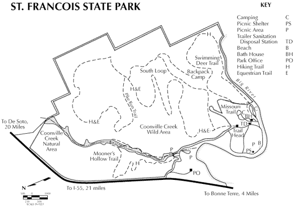
St. Francois State Park Trails
The wild forested terrain of the Pike Run Hills once was refuge for desperate Civil War outlaws. Today, these same hills in St. Francois State Park serve as a natural refuge from modern-day life for thousands of visitors each year.
Mooner’s Hollow Trail -- 2.7 miles
This trail follows the narrow, steep valley of Coonville Creek and its many rugged tributaries. The trail is so named because of the past activity of moonshiners in the area. Coonville Creek is part of the Coonville Creek Natural Area, so preserved because of it is one of the best examples of this type of natural community that can be found in the state. Crystal clear waters, scenic open woodlands and even a waterfall await you along the trail. This loop trail, marked in blue arrows, is moderate in difficulty and begins and ends in the picnic area.
Pike Run Trail -- 11 miles
This hiking and equestrian trail traverses much of the undeveloped 2,101-acre Coonville Creek Wild Area. It includes a 6.7-mile southern loop and a 4.3-mile northern loop. This region, formally known as the Pike Run Hills, encompasses a scenic and diverse remnant of Ozark terrain. Diverse forests and grassy forest openings, called glades, occur along the trail. Wildlife abounds in this expansive wilderness. This trail is moderate to difficult. The loops are signed with yellow arrows and the connecting trail with green arrows.
Beginning at the east end of the campground, this trail follows the Big River for approximately one mile and circles back along the hillside to its origin. Scenic bluff overlooks offer a panoramic view of the Big River valley. Trail users can take a step back in time as they pass by an area once used for surface lead mining. This trail is moderate in difficulty and signed with green arrows.
Missouri Trail -- 0.5 mile
The Missouri Trail is a short hiking trail that skirts the outer edge of the campground and passes through a wide range of vegetative associations. Within mere feet, hikers can view unique glade wildflowers and then experience a scenic open woodland reminiscent of pioneer days. This trail is easy in difficulty and is identified with orange arrows.
- Only hikers, equestrians and backpackers, as designated, are permitted on the park trails.
- All backpackers must register at the trailhead or park office before starting their trip.
- Camping is permitted only by backpackers on Pike Run Trail. No equestrian camping is allowed.
- Groups of seven or more persons are permitted to camp only in designated areas. While smaller groups are not required to use the designated areas, they must camp at least 100 feet from the trail, 200 feet from any major public-use area, and at least one-fourth mile from the trail entry/exit point.
- Campfires are prohibited. Stoves will be needed for cooking.
- Cutting implements such as saws and hatchets are not allowed on the trail.
- All pets must be leashed for their protection and that of other visitors and wildlife.
- All other rules and regulations pertaining to park use are applicable to trail users.
Directions to St. Francois State Park
From St. Louis
To get to St. Francois State Park, take I-55 south to the Festus/Crystal City exit. Exit onto U.S. Hwy. 67 south and travel approximately 22 miles. The entrance to the park is on U.S. Hwy. 67 on the left side. It is marked by a set of large brown highway signs.
From Cape Girardeau/Poplar Bluff
To get to St. Francois State Park, take U.S. Hwy. 67 north to Bonne Terre. The entrance to the park is on U.S. Hwy. 67, approximately four and one-half miles north of Bonne Terre, on the right side. It is marked by a set of large brown highway signs.
Cliff Cave County Park Trail
This 222 acre and heavily wooded park offers three main trails totalling about 4 miles.
The main 2 trails are Spring Valley Trail, which is about 2.75 miles in length and shorter Bluff Trail - only 1.2 miles in length.
Council Bluff Lake Trails Hiking
12 mile long Council Bluff Trail encircles the lake, with spurs to the campground. Trace Creek Section of the Ozark Trail is located just west of the recreation area.
Fees (Feb 2011):
Day-Use Fee: $3 per vehicle; $10 per bus; $20 for season pass. Pavilion - may be reserved; additional fee of $25 for the pavilion, plus $10 reservation fee.
Directions:
From St. Louis, take Hwy. 21 south to Potosi (60 miles); turn west on Hwy 8, then south on Hwy P at the first stoplight; continue south on Hwy P (12 miles) to Hwy C, then turn west for .1 miles to Hwy DD; turn south and continue to entrance (7 miles).

Contact Us~Copyright 2010-2011~Last Update Mar 31, 2012 7:27:56 AM